Holiday Resolution
The national park and forest reserve occupy the upper part of Mount Kilimanjaro adjacent to the Kenyan border just north of Moshi.
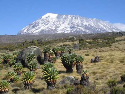
The national park comprises the whole of the mountain above the timberline and six forest corridors stretching down through the montane forest belt.
Kilimanjaro is a volcanic massif (last showing signs of major activity in the Pleistocene) which is not only the highest mountain in Africa, rising 4,877 m above the surrounding plains to 5,895 m, but also one of the largest volcanoes in the world.
It stands alone but is the largest of an east-west belt of volcanoes across northern Tanzania. It has three main volcanic peaks of varying ages lying on an east-south-east axis, and a number of smaller parasitic cones. To the west, the oldest peak Shira (3,962 m), of which only the western and southern rims remain, is a relatively flat upland plateau of some 6,200 ha, the northern and eastern flanks having been covered by later material from Kibo. The rugged erosion-shattered peak of Mawenzi (5,149 m) lies to the east. The top of its western face is fairly steep with many crags, pinnacles and dyke swarms. Its eastern side falls in cliffs over 1,000 m high in a complex of gullies and rock faces, rising above two deep gorges, the Great Barranco and the Lesser Barranco. Kibo (5,895 m), is the most recent summit, having last been active in the Pleistocene and still has minor fumaroles. It consists of two concentric craters of 1.9 km by 2.7 km and 1.3 km in diameter, with a 350 m deep ash pit in the centre. The highest point on the mountain is the southern rim of the outer crater. Between Kibo and Mawenzi there is a plateau of some 3,600 ha, called the Saddle, which forms the largest area of high altitude tundra in tropical Africa. There are deep radial valleys especially on the western and southern slopes.
Source: UNESCO


No comments:
Post a Comment